Free Pecine Videos
Pecine videos and clips for free download in 4K & HD for your next video project.
Sorry, no clips were found! Browse
Sponsored by iStock
LIMITED DEAL: Save 20% on 4K Video from iStock
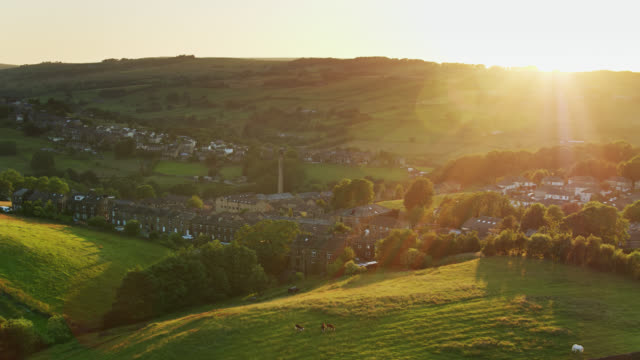

Aerial footage of Todmorden a small market town with a big industrial history. Nestled in the Pennine hills Todmorden is an ideal base for walking, with canals and old mills


Drone aerial footage of Yorkshire countryside valleys moorland and reservoir water. Looking over a dam wall. Shot at Marsden Village.


An aerial backward footage of a majestic mountain summit grassy slope with a trail path, blue sky and huge altitude white clouds 2


Aerial footage of Todmorden a small market town with a big industrial history. Nestled in the Pennine hills Todmorden is an ideal base for walking, with canals and longboats, barges.


An aerial reveal backward footage of a majestic mountain summit grassy slope with a stream, blue sky and huge altitude white clouds

An aerial forward footage of a majestic mountain summit grassy slope with a trail path, blue sky and huge altitude white clouds

Drone aerial footage of Yorkshire countryside valleys moorland and reservoir water. Looking over a dam wall. Shot at Marsden Village Huddersfield, West Yorkshire, UK

An aerial forward footage of a majestic mountain summit grassy slope with a trail path, blue sky and huge altitude white clouds 2


An aerial backward footage of a majestic mountain summit grassy slope with a trail path, blue sky and huge altitude white clouds


Aerial drone video footage of a reservoir dam wall showing overflow structures. Shot in near the village if Marsden in the United Kingdom.


An aerial sideway left to right footage of a rocky summit mountain with green slope and trail path under a majestic blue sky and huge altitude white clouds

An aerial sideway right to left footage of a rocky summit mountain with green slope and trail path under a majestic blue sky and huge altitude white clouds


Pennine Landscape Near Swaledale - Aerial View - England, North Yorkshire, Richmondshire District, United Kingdom

Pennine Landscape Near Swaledale - Aerial View - England, North Yorkshire, Richmondshire District, United Kingdom


Whitworth Mill Town - Aerial View - England, Calderdale, helicopter filming, aerial video, cineflex, establishing shot, United Kingdom


An aerial forward reveal footage of a mountain valley with grassy and stony slopes, trees and mountain range summits under a majestic blue sky and some white clouds


An aerial backward reveal footage of a mountain valley with grassy and stony slopes, trees and mountain range summits under a majestic blue sky and some white clouds

An aerial forward footage of a rocky summit mountain with green slope and trail path under a majestic blue sky and huge altitude white clouds

An aerial sideway (left to right) footage of a mountain valley with grassy and stony slopes, trees and mountain range summits under a majestic blue sky and some white clouds

An aerial sideway (right to left) footage of a mountain valley with grassy and stony slopes, trees and mountain range summits under a majestic blue sky and some white clouds


Slow moving river stream. Camera moving down a moorland footpath and across a lush valley in West Yorkshire, England. Moorlands above Marsden Village.


Drone footage of Saddleworth Moor, and motorway the M62 Windy Hill with blue sky in the summer

Aerial View of Saddleworth Moor, and motorway the M62 Windy Hill and Lake with blue sky horizon


Drone footage of Saddleworth Moor, and motorway the M62 Windy Hill with blue sky on the horizon


Aerial View of Saddleworth Moor, and motorway the M62 Windy Hill with blue sky on the horizon

